Tucked away in the southwestern foothills of the Ouachita Mountains is a truly unique and peaceful area known as the Caney Creek Wilderness. The place is full of creeks, rivers, drainage’s, geological rock formations, steep valleys, sweeping mountain views, loads of mountain hiking trails, and magnificent backroad driving.
For me, coming out of Hot Springs, this area is not but a short hour / hour and a half drive (depending on which area of the Wilderness I explore). I’ve been in this area before practicing waterfall photography back in late Autumn, so this trip was mostly familiar territory.
From Highway 246 in Athens, Arkansas (close to Glenwood, Arkansas) I would turn off onto Forest Road #38 towards Shady Lake Campground. This road will bring me to the Buckeye Mountain Trailhead where I would embark on what’s considered a difficult 9.6 mile loop hike. Once completed, I would stop on a (different) way out and check out the remaining waterfalls in the area that are all roadside or a short hike from the car.
The weather for the day was perfect for my favorite style of photography – shooting waterways – Fog, Overcast, & Mist. The foggy overcast added a moody vibe to all the shots. I’ve always said a moody Arkansas is my favorite Arkansas. The mist provided just enough moisture to make the surroundings wet. In combination with the shadow-less, soft lighting overcast, it made the gorgeous lime green new growth colors of Spring all the more vibrant set against the rock strewn mountains. But because of this weather, the scenic overlooks of the mountains were impossible to shoot. The fog was incredibly too thick to even see anything much further past 10 – 15 feet ahead of you.
As a natural lighting based landscape photographer, in this kind of scenery, the ideal weather for photography along the creeks doesn’t always work for the overlooks and vice versa. But, still the fact that this place offers both variety’s is a big bang for you buck. The hike I went on can really be done in two days, and a lot of people will do it that way. Campsites are EVERYWHERE, not only on the trail, but also on the side of the Forest Road’s throughout the area. You could even time the hike for a day of ideal weather exploring along the creek bed and another day exploring the ridge top views of the Ouachita Mountains. For me, I wanted to do this particular hike in one day, to see if I could do it, how well I could do it and get a better understanding of what my limits may be. And I’ve learned that if you’re dedicated enough, you can see every significant waterfall in this area in ONE day!!!
Shady Lake Recreation Area
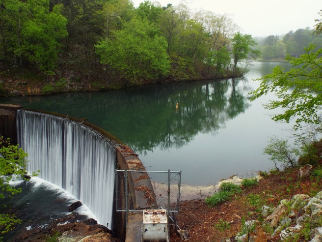
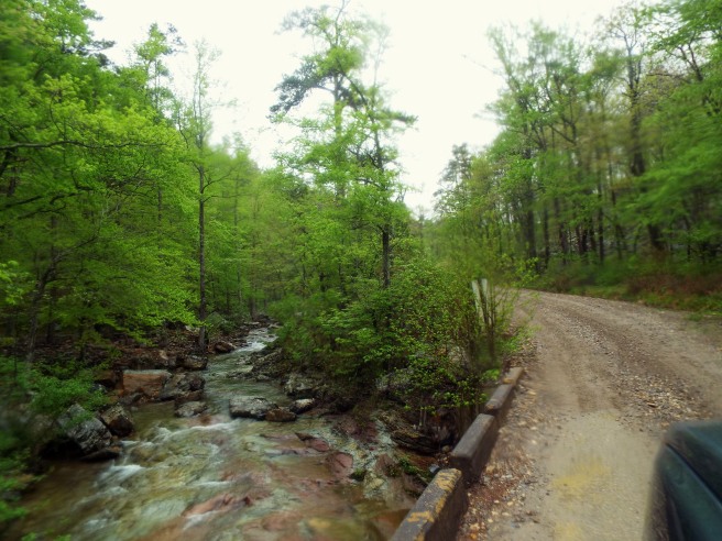
2.2 miles west out of Athens, Arkansas on Highway 246, you’ll head North on Forest Road #38 towards the Shady Lake Recreation Area. Once you get to the historic dam after roughly 3 miles (pictured here), the scenery from this point onward is absolutely top-notch. This is a roadside attraction on the way into the recreation area. I wouldn’t normally share something man made, certainly not in a gallery, but for blog purposes I will. Shady Lake is a small but scenic 25 acre lake with trails that traverse Saline Creek (mountain biker friendly), a sweet swimming area, and a really nice sized campground. Great for families, and not to mention the roadside waterfalls further up the road provide easy access for people of all ages.
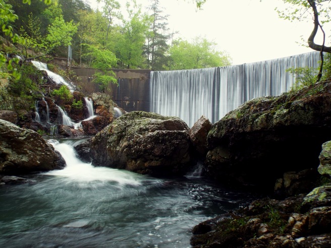
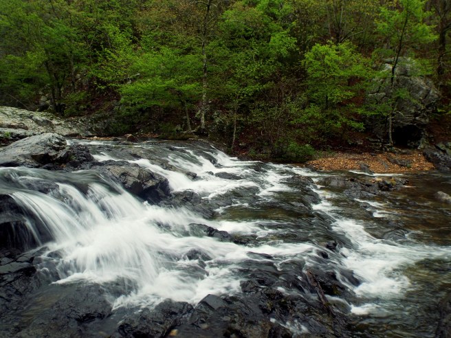
A short hike downhill from the parking spot / overlook. If you’re looking to get into shooting waterfalls / waterways but want to practice more – this is the place to do it. I use to come out here when practicing as it was a short drive from the house and provided constant flow from the dam’s spillway. The cascade to the left of the dam is the Shady Lake Cascade. The cascade is considered as one of six significant waterfalls in the area. Unless you’re willing to get knee deep into cold water (which I wasn’t), then it is very hard to photograph that fall without having that dam wall in the photo.
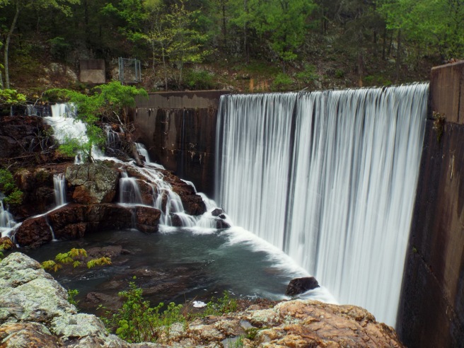
A better view of the Shady Lake Cascade after climbing up the slick rocks back towards the overlook / parking spot.
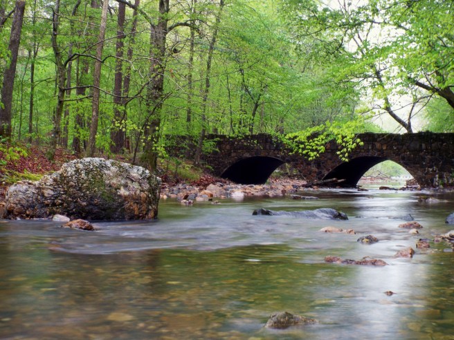
When leaving the Shady Lake Dam heading further up Forest Road #38 you can make a quick left to check out the Shady Lake Campground if you like. I’ve explored this campground before and always favored this bridge scene along Saline Creek. I decided to make a quick stop before my hike to snap this photo.
The Buckeye Trail Hike
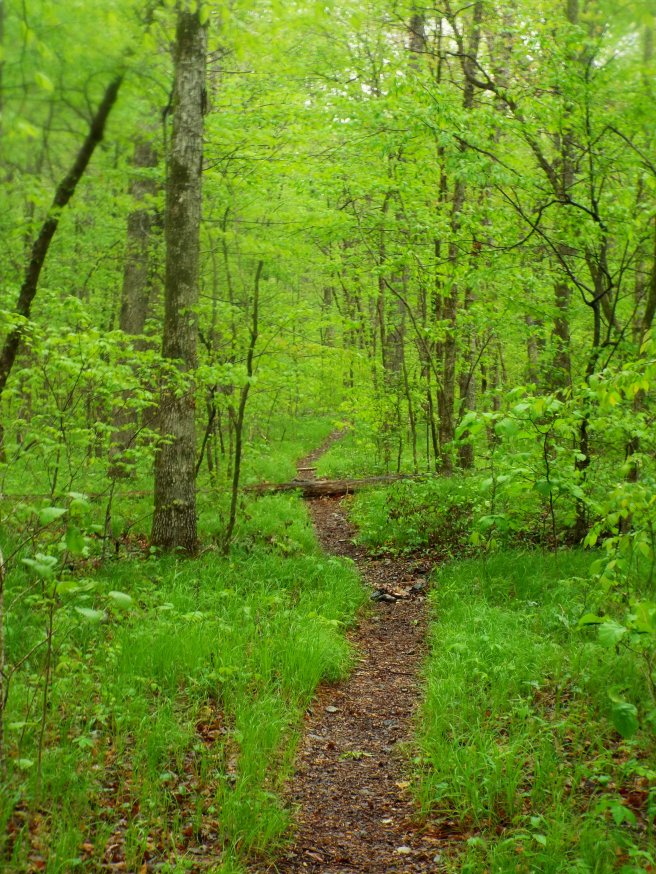
The Caney Creek Wilderness is the oldest in Arkansas. A massive 14,422 acre area that contains the first backpacking trail built in the state. About 8 or 9 miles up Forest Road #38 from Highway 246, past the Shady Lake Recreation Area, past the turnoff for Bard Springs Campground, past the parking for Trailhead Falls (which I will come back to), past the East Caney Creek Trailhead, and on up at the top of the hill is the Buckeye Trailhead. For the 9.6 mile loop hike you will begin here at the Buckeye as it does a lot of gradual up and down hiking along a VERY long ridge top. Tons of geological rock formations along the way, wildflowers in open spaces, and COUNTLESS amounts of scenic overlooks. Due to the weather, I didn’t get to see any, and by the time the fog had lifted I had already made my way down from the ridge top. Somewhere around 3.4 miles the trail turns left, leaves the ridge top and begins a gradual but rapid descent down into the Katy and Caney Creek drainages. The highlight of the trip and a good halfway point down there is Katy Falls. From Katy Falls, you turn left and begin to follow the Caney Creek trail all the way to the East Caney Creek trailhead. From here I will have to hike another mile or so on UP Forest Road #38 back to my truck at the Buckeye Trailhead.
Now, most people spend all weekend out here doing the Buckeye Trail one day, camping out that night, and then heading back via the Caney Creek trail or however which way they want to go as other trails meander through the area as well. Not to worry though as it’s really not all that confusing. For me though, doing the whole thing in one day sounded like a challenge and I personally like a challenge and the workout.
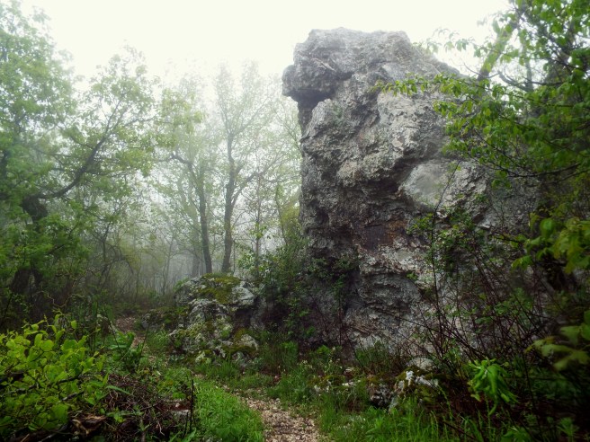
The Buckeye trail is loaded with awesome rock features like these. This is somewhere along the halfway point from the Buckeye Trailhead to Katy Falls. A very easy going trail, but it’s steadily up and down along a ridge.
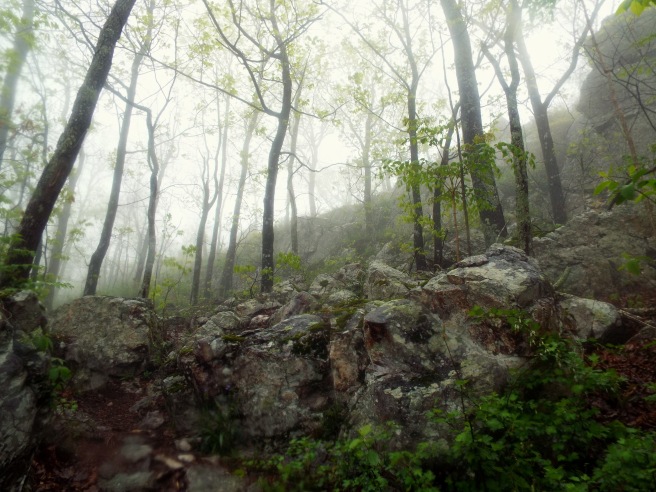
The trail is FULL of overlooks, from open spaced ones to portions seen through the breaks in the trees. As you can tell from the fog of these photo’s, that I wasn’t able to see any of them. I’d like to return to this portion of the trail later on in better weather conditions for this section and truly see it.
Shortly after leaving the ridge top, I start to make my way down the ridge and into the Katy and Caney Creek drainages. This area is really boulder / rock strewn throughout and with incredibly steep hillsides. The trail down to the bottom is quick in momentum, but it’s well worn and pretty lengthy as you gradually make your way down to Katy Falls.
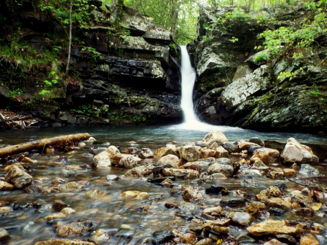
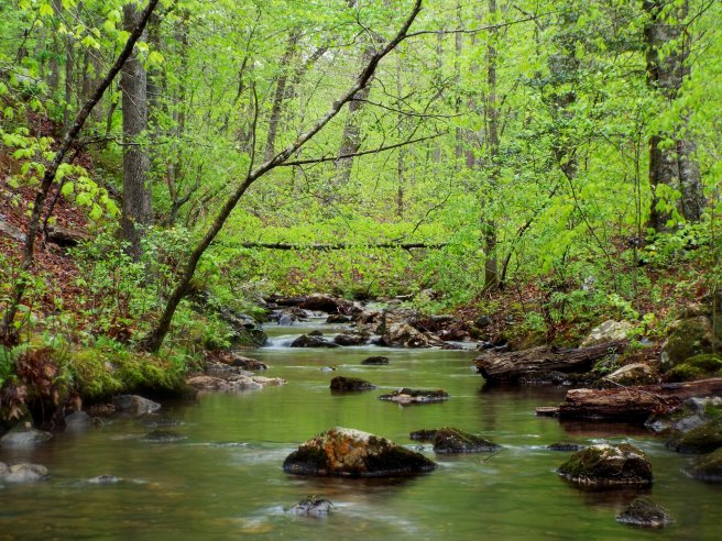
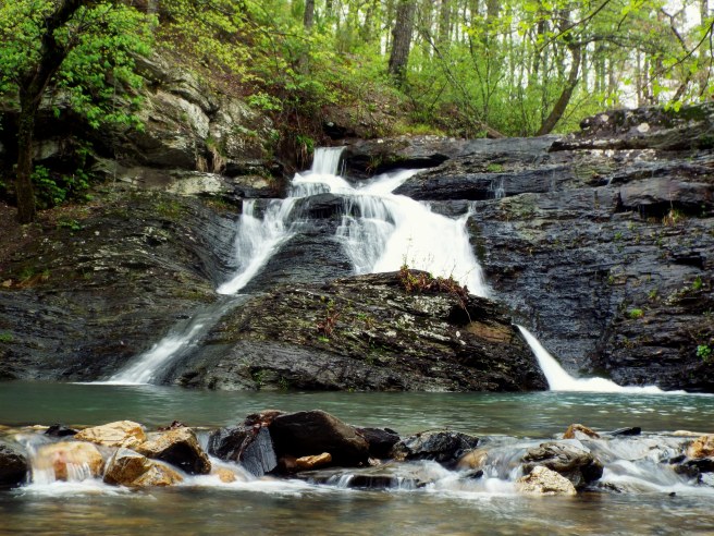
Katy Falls
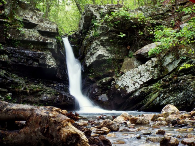
You know where Katy Falls is before you ever even get to it. You can hear it on your way down. I must say this waterfall isn’t the biggest (it really is bigger in person though), but it’s an absolute personal favorite of mine because of how rewarding it is. From the Buckeye Trailhead to this point down here, it’s been 4 and a half miles of up and downing with a quick descent. I started the trail right at 8:30 a.m. and finally made it to the falls at 11:30 a.m. I have another 5 miles to go to complete this hike.
So after that kind of a journey, finally making it to the bottom of Katy Falls, soaking in the surrounding scenery to take a break was an overwhelming reward. I spent a good 30 minutes here, eating lunch, shooting the waterfall, and chatting with two guys in a hammock down here. They were the only other people I had come across on this hike.
Spring time in the Southwestern Ouachita’s is a lot of lush lime green colors right now. I felt like I was in a tropical rainforest. Katy Falls certainly gave off that impression. A bonus that it’s miles deep into the Caney Creek Wilderness.
The Caney Creek Hike
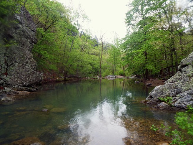
Shortly after leaving Katy Falls, you’re heading downstream along Katy Creek until it meets with Caney Creek. This is the scene crossing Katy Creek and looking upstream as you begin you’re way east along the Caney Creek trail.
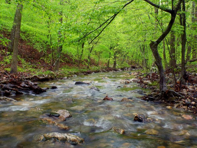
The Caney Creek trail is gorgeous! I cannot express that enough. It’s full of drainages that deposit into the Caney Creek the whole entire way. The only disappointment is that more often than not, the trail doesn’t actually follow along the creek, but up above and away from it. Regardless the scenery is top notch, reminiscent of the Ozark Mountains of Northwest Arkansas but given it’s own uniqueness and flavor.
This is what the trails look like along the creek bed, very easy going for the most part, but no less scenic. At this point I’ve hiked close to 8 miles and have close to 2 left. Shortly after hiking through the lush creek bottom and all of it’s pretty cascades and mini bluffs, you begin to climb up a side drainage back to the East Caney Creek Trailhead. This is the point in time where the distance and the constant up’s and down’s had me thinking explicit words whenever I’d see another hill. Nonetheless I powered through until I made it back to Forest Road #38. I reluctantly pushed through the last mile UP the steep gravel road back to the truck. Sure was glad to get back to the vehicle. I started the trail at 8:30 a.m. and finished right at 3:00 p.m.
I’ve been tracking my progress on a GPS app on my phone for the entire duration of this hike. I explored a little more off trail on both the Buckeye and the Caney Creek portions. I’m not sure how accurate the app is but here’s the resulting data.
Distance: 11.36 miles / Total Time: 6:39:41 / Average Pace: 35:10 minutes per mile
Blaylock Creek Waterfalls
Heading south from the Buckeye Trailhead on Forest Road #38 you’ll make your way down to East Caney Creek Trailhead. A couple hundred yards after that through the brush to your right is the waterfall Trailhead Falls. The fall is not on Blaylock Creek itself but pours into it from a drainage just across the creek, so usually you can see it from your vehicle on the road. However, today Blaylock Creek really was not flowing all that much. I didn’t even bother for a photo.
I keep heading on down Forest Road #38 as if going back to the Shady Lake Recreation area. Instead, shortly after Trailhead Falls, I turn onto Forest Road #106 (aka Blaylock Creek Road). You pass the Bard Springs Campground early on (another great place to practice waterfall photography) as you make your way down the 9 or 10 mile road. This road is one of my favorite drives for its scenery. Spring time and Autumn are real treats as you go along and cross the creek multiple times. At times you’re crossing narrow low bridges, and sometimes easing around sharp curves that hang in the upper ridges of the creek. You’ll see lots of pull offs with full or non full campsites and even parking areas for other trailheads.
3/4 of the way down Forest Road #106 is one of the pull offs mentioned that brings you right to the impressive Blaylock Creek Falls. Another fall that comes in from a drainage across the creek, this time taller, but with it’s own personality unique from Trailhead Falls. When I checked on this one, it was but a trickle like Trailhead so I didn’t bother for a photo again. I wanted to include these in this blog however, as they are right in the same area and the drive alone is worth it. A spot that you really have to see for yourself.
Continuing down Forest Road #106 shortly after Blaylock Creek Falls and you will find yourself at the Albert Pike Recreation Area, a gorgeous area along the Little Missouri River. At this junction, Blaylock Creek Road ends and you can either take a right on Highway 369 towards Langley, Arkansas or take a left for a quick trip to Little Missouri Falls.
Little Missouri Falls
Continuing up Highway 369 from the Albert Pike Recreation Area, the road suddenly turns gravel and into Forest Road #73. Following for another 3 miles and I turn left onto Forest Road #43 that leads to the turnoff for Little Missouri Falls. This portion of the road (pictured here) follows and crosses Crooked Creek. A spectacular portion loaded with cascades and I mean A LOT. High waters would look really spectacular in this surrounding area.
Getting to Little Missouri Falls is easy. Signs lead directly to it. Once at the parking lot, the surrounding area is paved, with stairs, overlooks and steps down to the base. Well maintained and accessible for most. It’s not but a quarter of a mile round trip to see it. This is only a portion of Little Missouri Falls, which is more like a really big and really fantastic cascade. I can imagine high water would really make it special. I’d go here real early in the morning for a chance to have it all to yourself.
The view downstream from the base of Little Missouri Falls.
Crooked Creek Falls
From the turnoff of Little Missouri Falls, I’ll continue up Forest Road #43 along Crooked Creek for another mile and a half until I reach it’s waterfall. You can park along the road here and easily drop down to the base. Another one that would look stunning in high water. From this point, I continue up until I reach Highway 8, which leads me towards Glenwood, Arkansas. This is closer to home for me than it was from the Shady Lake Recreation area. I’ve made somewhat of a loop exploring every significant waterfall in this area while getting one hell of a good workout on a lengthy hike.
The Caney Creek Wilderness is truly something unique no matter what season you’re in, but I must say Spring is my favorite. I would love to return and make a weekend of it. It’s location in southwestern Arkansas is great for people from Louisiana, Texas and Oklahoma to get some real mountain hiking in.
The key to my success today was keeping a consistent pace. I can apply this to other aspects of life in the sense that success will always come to those who put the work in. There’s no way you can fail if you stay consistent. I always choose quality over quantity.
GPS COORDINATES
Latitude / Longitude
Shady Lake Cascade & Dam: – 34.35960, 94.02810
Buckeye Trailhead: – 34.40897, 094.02807
Katy Falls: – 34.39692, 94.08030
Trailhead Falls: – 34.39593, 94.02123
Blaylock Creek Falls: – 34.37091, 93.92258
Little Missouri Falls: – 34.42162, 93.91875
Crooked Creek Fall: -34.42700, 93.88558
______________________

Bryce, enjoyed your blog on the Buckeye/ Caney area. I help maintain that trail system, we were just back there a couple of weeks ago doing trail work. I know of several other waterfalls and interesting drainages in that area if you’re interested. Great photography work!
Mark
LikeLike
Mark
I sent you an email. Certainly interested!
LikeLike
Beautiful photography and great write up! Thanks for posting this.
LikeLiked by 1 person